


Powerful Cold Front Brings Snow Squalls and Whiteout Conditions
A powerful cold front is making its way across the country with the possibility of several snow squalls developing along the way. Early Thursday, this front is beginning to move into the Northeast, and the fast-hitting bursts of snow could create extremely dangerous whiteout conditions and impact travel.
Snow squall threat(FOX Weather)
Cold Front and High Pressure System
A large cold front is continuing its shift east, extending across the Great Lakes and into the Plains.
A strong area of high pressure is tailing that front and will quickly make its way into the middle of the U.S. As the cold front makes its way East, it will be accompanied by an arctic air mass containing some of the coldest temperatures this season, along with moisture, allowing the cold front to act as a trigger for snow showers.
Potential Ice Threat and First Snow of the Season
POTENTIAL ICE THREAT, FIRST SNOW OF SEASON LOOMS FOR MID-ATLANTIC, CAROLINAS AMID ACTIVE LA NIÑA WINTER
This image shows a life-threatening snow squall just west of Grand Forks, North Dakota, on Wednesday, Dec. 4, 2024. (@NWSWPC/X)
Ahead of the system, it will be cold and calm, but as the system moves to the south, a sharp rise in winds will likely begin and temperatures will tumble.
Northeast Interstate Forecast
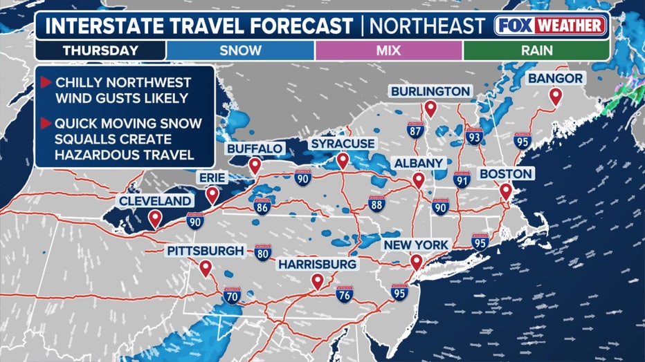
Northeast interstate forecast(FOX Weather)
According to the FOX Weather Center, the threat of snow squalls ramps up on Thursday when the traveling cold front becomes a true artic front. Just enough moisture will accompany this system to allow snow to develop, with the peak expected to happen in the morning and afternoon hours.
Whiteout Conditions and Lake-Effect Snow

Throughout the day, whiteout conditions are possible along major U.S. Interstates, including I-90, I-81 and I-80, with some areas around the Great Lakes and in the Northeast forecast to see several inches of snow.

Winter Weather Alerts(FOX Weather)
With winds switching out of the west and northwest, cold air will move over Lake Erie and Ontario, which increases the risk of Lake-Effect Snow downwind. Winter Weather Advisories have been issued for portions of Western New York, including Buffalo, Watertown and Syracuse, where 3-5 inches of snow is likely.
Stay Updated
LINK: Get updates and more at foxweather.com
Conclusion
The powerful cold front moving across the country is expected to bring snow squalls and whiteout conditions, making travel extremely dangerous. It is essential to stay updated with the latest weather forecast and advisories to ensure safety. The cold front is expected to move into the Northeast, bringing with it arctic air and moisture, leading to snow showers and Lake-Effect Snow.
Frequently Asked Questions
Q: What is a snow squall?
A: A snow squall is a brief, intense snowstorm that can produce heavy snowfall and strong winds, leading to whiteout conditions.
Q: What areas are expected to be affected by the cold front?
A: The cold front is expected to affect the Northeast, Great Lakes, and Plains, with areas around Lake Erie and Ontario at risk of Lake-Effect Snow.
Q: How much snow is expected?
A: Some areas are expected to see several inches of snow, with Winter Weather Advisories issued for portions of Western New York, including Buffalo, Watertown, and Syracuse, where 3-5 inches of snow is likely.
Q: How can I stay updated with the latest weather forecast?
A: You can stay updated with the latest weather forecast and advisories at foxweather.com.

