


La Niña Returns: What It Means for the US Winter
COLLEGE PARK, Maryland – La Niña has returned for a second consecutive go-around this autumn and winter, and it could have a noticeable influence on seasonal weather patterns.
Water temperatures in the central Pacific Ocean dropped to 0.5 degrees Celsius below average (-0.9 degrees Fahrenheit) in the latest measurements by NOAA’s National Climate Prediction Center, triggering a La Niña Advisory on Thursday.
What is La Niña?
La Niña is part of a five-to-seven year cycle known as the El Niño Southern Oscillation, or ENSO, that is generated from a change in water temperatures in the central Pacific Ocean. When the waters cool below 0.5 degrees C of normal, it’s considered La Niña, while being warmer than 0.5 degrees C is known as El Niño. When it’s in between, it’s called “neutral” conditions, or sometimes informally called “La Nada”.
Sea surface temperatures in Pacific. (FOX Weather)
Researchers have found these changes in ocean temperatures have a cascading effect on weather conditions across the tropics in the Pacific Ocean, which in turn have a profound effect on global weather patterns by altering jet stream patterns.
Typically, La Niña causes a stronger dip in the Polar Jet Stream across the northern U.S., with the Pacific Jet Stream aimed toward the West and Northwest coastlines, according to the FOX Forecast Center.

What La Niña Means for US Winter
La Niña winters have historically brought generally cooler, wetter conditions to the North and milder and drier conditions to the South. It can keep a drought going in the Southwest while the Pacific Northwest basks in an above-average mountain snowpack.
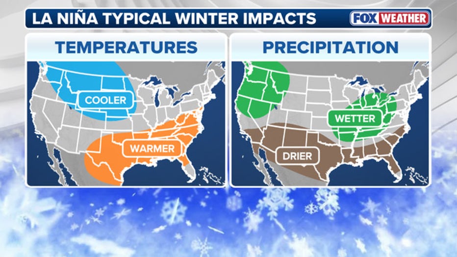
La Niña winter impacts. (FOX Weather)
The upper Northern Plains are usually in for a colder winter (more than the typical cold) while the Great Lakes region also tends to lean on the wetter side. The Southeast and deep Southwest into Texas usually end up with a mild and dry winter.
It’s essential to note that while La Niñas amount to a “weighing of the dice” toward these overall trends, other large-scale factors and short-term weather patterns can override La Niña’s effects. For example, the Northern Plains could still go through a mild stretch or Texas and the South could endure a rainy stretch.
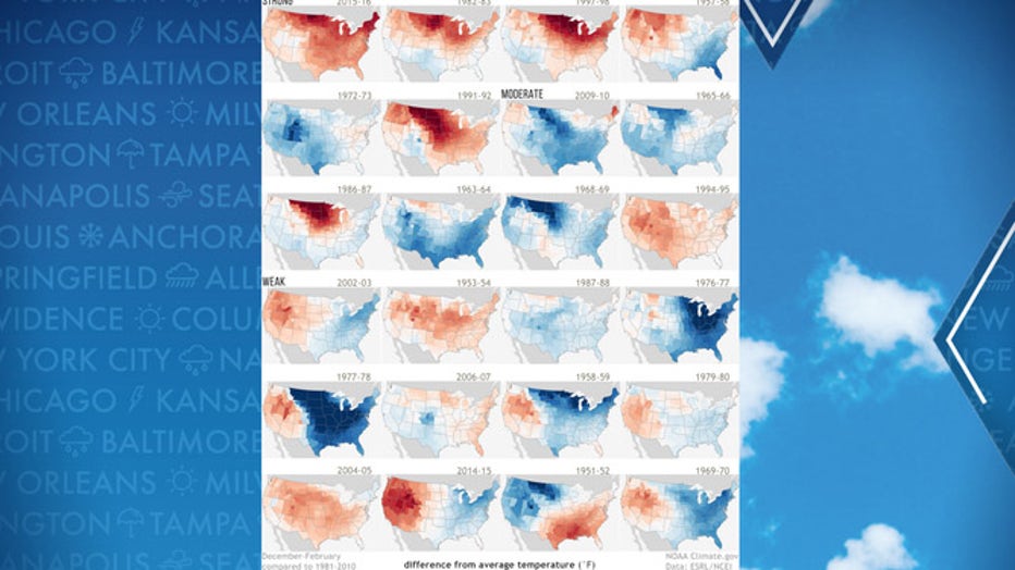
Winters of weak, moderate and strong El Niños. (FOX Weather)
La Niñas are also synonymous with more active hurricane seasons in the Atlantic tropics basin, thanks to weakening wind shear, but this La Niña is likely too late to have much of an influence on the waning days of this year’s hurricane season.
This La Niña Appears to be a Short-Timer
Another factor in play this winter is that La Niña is forecast to remain on the weak side, with sea surface temperatures in the Pacific predicted to drop no more than -0.9 degrees C below average.
“A weak La Niña would be less likely to result in conventional winter impacts, though predictable signals could still influence the forecast guidance,” NOAA forecasters wrote in their monthly ENSO update.
In addition, forecasts show La Niña will be relatively short-lived, with a 55% chance ocean waters will warm and return to the ENSO phase to “neutral” by the middle of winter.
If this all sounds familiar, it’s a somewhat similar script to last winter, which saw a weak La Niña – albeit delayed until late in the winter – briefly last until spring before returning to neutral conditions.
How is La Niña Influencing the Seasonal Forecasts?
NOAA says the arrival of La Niña has indeed influenced their seasonal forecasts for this autumn and winter. In particular, their 90-day forecasts spanning November-January and December-February are weighted toward La Niña tendencies.
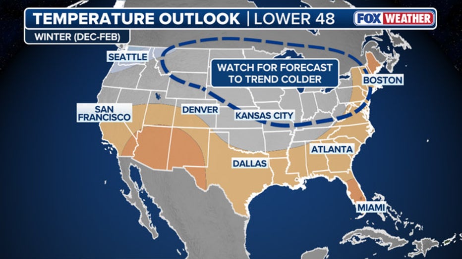
Dec. 2025-Feb. 2026 seasonal outlook. (NOAA Climate Prediction Center / FOX Weather)
Their latest updates were from Sept. 18 — before La Niña was declared — but they were already trending in the assumption La Niña would arrive and have predicted likely below average temperatures in areas of the North — particularly the Pacific Northwest — and above average temperatures in the South.
The precipitation forecast also has a La Niña feel to it, with above average rainfall/snowfall across the North and drier conditions along the South.
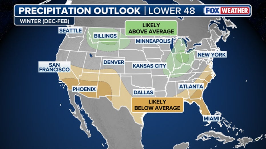
Dec. 2025-Feb. 2026 seasonal precipitation outlook. (NOAA Climate Prediction Center / FOX Weather)
NOAA’s next seasonal forecast updates come on Oct. 16 and may show even more of an expected La Niña influence then.
Once this La Niña fades in the winter or spring, NOAA’s long-term forecasts indicate neutral conditions will likely persist well into the spring, but ENSO influences begin to fade in the spring in summer patterns in the Continental US.
Conclusion
In conclusion, La Niña has returned for a second consecutive year, and its effects on the US winter are expected to be significant. While the impact of La Niña can be overridden by other large-scale factors and short-term weather patterns, it’s essential to understand the potential effects of this climate phenomenon on seasonal weather patterns. By staying informed and up-to-date on the latest forecasts and predictions, individuals can better prepare for the potential impacts of La Niña on their region.
Frequently Asked Questions
Here are some frequently asked questions about La Niña and its effects on the US winter:
Q: What is La Niña?
A: La Niña is a climate phenomenon characterized by cooler-than-average sea surface temperatures in the central Pacific Ocean. It is part of a five-to-seven year cycle known as the El Niño Southern Oscillation, or ENSO.
Q: How does La Niña affect the US winter?
A: La Niña winters have historically brought generally cooler, wetter conditions to the North and milder and drier conditions to the South. The upper Northern Plains are usually in for a colder winter, while the Great Lakes region tends to lean on the wetter side.
Q: Is this La Niña expected to be strong or weak?
A: This La Niña is forecast to remain on the weak side, with sea surface temperatures in the Pacific predicted to drop no more than -0.9 degrees C below average.
Q: How long is this La Niña expected to last?
A: Forecasts show La Niña will be relatively short-lived, with a 55% chance ocean waters will warm and return to the ENSO phase to “neutral” by the middle of winter.
Q: How will La Niña influence the seasonal forecasts?
A: NOAA says the arrival of La Niña has indeed influenced their seasonal forecasts for this autumn and winter. In particular, their 90-day forecasts spanning November-January and December-February are weighted toward La Niña tendencies.

