
Chicago’s Unpredictable Weather: From 94 Degrees to Chilly Spells
Introduction to Chicago’s Unpredictable Weather
Last week, Chicago had its earliest 94-degree day in the last 76 years, and yet, we’re back to wearing hats and coats under umbrellas this week.
Our afternoon temperatures have been in the 50s the past few days, which you may be surprised to hear isn’t that unusual. Chicago’s average last day with a high temperature below 60 degrees is May 23. The records for lowest maximum temperatures this week are between 40 degrees and 42 degrees, but those records are all between the years 1883 and 1900.
The chilly spell this week could be perceived as more unusual because of how hot it was last week, when the area reached 94 degrees on May 15.
Understanding the Weather Patterns
The reason for this fluctuation in temperature is due to the jet stream, a fast-moving band of air that plays a significant role in determining the weather. The jet stream can cause temperatures to rise or drop significantly, depending on its position and movement.
In Chicago, the jet stream is responsible for the unpredictable weather patterns, and this is why the city experiences a wide range of temperatures throughout the year.
When Will Things Warm Up Again?
So, when will things warm back up? Chicago hasn’t had a daily high temperature in the 50s in the month of June since 2001, so it’s extremely rare for things to stay this chilly much longer.
In fact, the consensus of long range forecast models and the Climate Prediction Center is a pivot to above-average warmth as we head out of May and into June.
We still have another five to seven days of below-average temperatures – mostly in the 60s – but a prolonged period of “ridging” in the jet stream is expected to bump temperatures up in a big way around May 30 and beyond.
Temperature Outlook
If the models stay true, and the jet stream doesn’t buckle, temperatures would reach 80-85 degrees for several consecutive days through the first week of June.
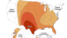
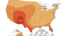
The three- to four-week outlook from the Climate Prediction Center for the Chicago area is above-average temperatures and slightly above-average precipitation.
The forecast for the month of June is above-average temperatures and near-average rainfall.
Conclusion
In conclusion, Chicago’s unpredictable weather is a result of the jet stream and other atmospheric conditions. While the city experienced a rare 94-degree day in May, it’s not uncommon for temperatures to fluctuate significantly. As we head into June, temperatures are expected to rise, and the city can expect above-average warmth and near-average rainfall.
Frequently Asked Questions
Q: What is the average last day with a high temperature below 60 degrees in Chicago?
A: The average last day with a high temperature below 60 degrees in Chicago is May 23.