
Hurricane Helene to Bring Significant to Catastrophic Flooding to Southeast
Severe Impacts Expected Across East Coast
While Florida is preparing for the landfall of Hurricane Helene, the size of the storm means widespread impacts will be felt across the eastern U.S. late this week, including damaging winds, flooding rain, and possible tornadoes in states well into the Southeast, mid-Atlantic, and Midwest.
Newspaper Offices Warn Residents of Catastrophic Flooding
National Weather Service offices across the Southeast, including Greenville, South Carolina, are issuing Flood Watches and Warnings to warn residents of potentially catastrophic flooding. Ahead of Helene’s rainfall, the region is expected to get several inches of rain from thunderstorms.
Rainfall Expectations
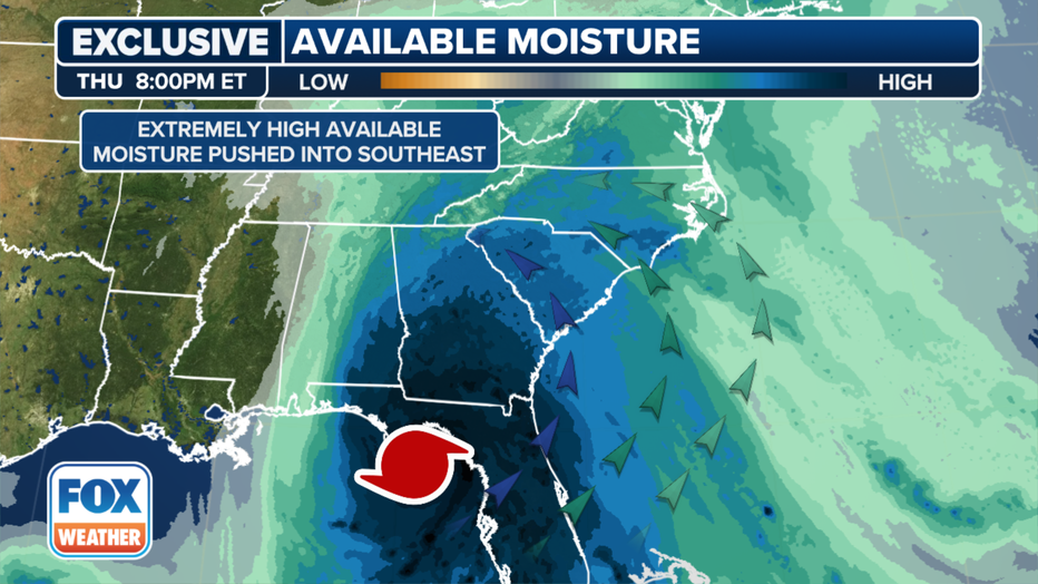
The biggest implications for Helene post-landfall will be the rain totals forecast across multiple states from Georgia to Kentucky and Virginia as Helene taps into available moisture in the Southeast and pushes toward the Appalachian Mountains. Forecasters are warning of total rain accumulations of 5-10 inches, with isolated totals near 15 inches. Cities such as Atlanta and Augusta in Georgia and Knoxville and Chattanooga in Tennessee are among those at the greatest flash flooding risk over the next five days.
Tornadoes May Occur in Western Florida Peninsula and Southern Alabama
The NHC is warning of a risk of tornadoes, including one or two that may occur in western Florida Peninsula and southern Alabama on Wednesday. This risk will increase on Thursday, expanding across Florida and into parts of Georgia and South Carolina.
Florida and Southern States Prepare for Impact
Ahead of Helene’s impacts, the governors of Georgia, South Carolina, and North Carolina have declared states of emergency. Georgia Power is also prepared to cut off power if necessary and recommends residents stock up on food, water, and medication.
Flight Disruptions Expected
Travelers are also advised to prepare for flight disruptions as Hurricane Helene moves through the Southeast. Atlanta International Airport is warning airline travelers that the impacts could have a ripple effect across the Southeast.
Flash Flood Outlook for Thursday
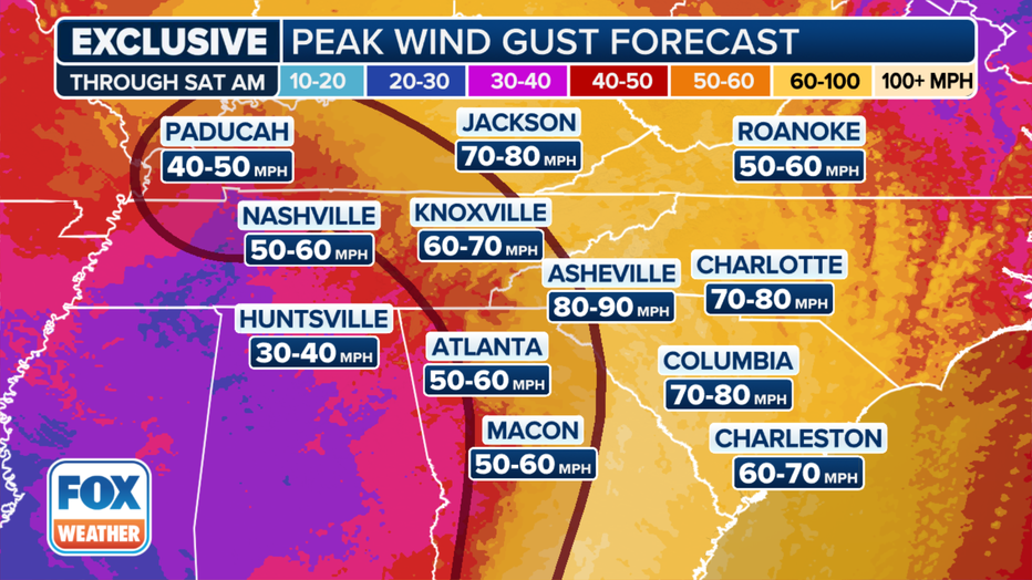
Inland Wind Forecast
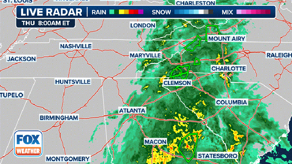
Radar Animation of Helene’s Track
FAQs:
- Q: What impact can I expect from Hurricane Helene?
- A: Expect widespread rain, damaging winds, and possible tornadoes across the Southeast, mid-Atlantic, and Midwest.
- Q: Are any areas under warning?
- A: Yes, the National Weather Service has issued Flood Watches and Warnings for the Southeast and Florida.
- Q: How much rain am I expected to receive?
- A: Forecasts predict total rain accumulations of 5-10 inches, with isolated totals near 15 inches.
- Q: What should I do in preparation for Helene?
- A: Make sure to have a emergency kit with supplies, water, and food, as well as a plan to evacuate if necessary. Keep your phone charged and ensure your gas tank is at least half full. Stay tuned to local news for updates.